Municipality:Karlstad
| Karlstad | |
|---|---|
 | |
 Coat of arms of Karlstad | |
| Country | Sweden |
| Region | Värmland |
| Number of zones | 515 |
| Maximum PPH | 1929 |
| Last updated | 2022-01-23 |
Karlstad is a municipality in the region of Värmland in Sweden. The municipality has about 95,200 inhabitants and is located in its entirety in the province of Värmland.
Contents
Location[edit]
Karlstad municipality is located in the southern parts of the province Värmland, on the northern shore of Lake Vänern. The municipality borders the municipalities Grums in the west, Hammarö in the south, Kristinehamn, Storfors and Filipstad in the east and Forshaga, Hagfors and Kil in the north and has a maritime border to Säffle in the southwest, all in Värmland's County.
Urban areas[edit]
The municipality's central town Karlstad is located on the northern shore of Lake Vänern. Karlstad is the city of residence for Värmland County and the diocesan city for Karlstad diocese and since 1999 the university city. Karlstad is Sweden's 20th largest urban area with 65,856 inhabitants (2020).
Other urban areas in the municipality are Alster, Blombacka, Edsgatan och Långenäs, Edsvalla, Edsvalla Övre bruket, Molkom, Norsbron, Råtorp, Skattkärr, Skåre, Vallargärdet, Vålberg och Väse.
Zones[edit]
There are 515 turf zones in the municipality of Karlstad, ten of which are counted as winner zones, four water zones, three train station zones, five monument zones, eleven holy zones, 22 bridge zones and three ruin zones.
The most taken zone is KarlsPlaza which is located at the main square in the center of Karlstad.
Year in parentheses indicates year of creation.
 Winner zones[edit]
- ABECE (2015) - Round 64 by ABECE
- ABECE001 (2018) - Round 91 by ABECE
- Jajk (2019) - Round 109 by Jajk
- JomiiRainbow (2017) - Round 78 by Jomii
- Jomiizone (2016) - Round 76 by Jomii
- OhMyJajk (2020) - Round 121 by Jajk
- Simpson (2016) - Round 74 by simpson
- Simpzon (2017) - Round 86 by simpson
- Simpzone (2018) - Round 93 by simpson
- WilliamsFyra (2016) - Round 77 by Tasse74
 Water zones[edit]
- Alstern (2010)
- BodyZone (2011)
- Mariebergsvik (2015)
- SkutVatten (2015)
 Train station zones[edit]
- KalleSpårarUr (2012) - Formerly called KalleSpårarUt
- VälsvikenStn (2014)
- VäseStation (2015) - Formerly called VäseNorra
 Monument zones[edit]
- FrödingeSten (2014)
- Kasernstenen (2014) - Formerly called Kasernhöjden and lacked attribute.
- LataStatyn (2013)
- Residenset (2012)
- TrossnäsFält (2019)
 Holy zones[edit]
- AlsterKyrka (2015)
- Feskekörkan (2020)
- GravaKyrka (2015)
- HeligaHagen (2016) - Formerly called HolyKF
- KarlCathedral (2012)
- MosaiskaZonen (2017)
- NyedsKyrka (2013)
- Rudzon (2014)
- VåxnäsZone (2012)
- VäseKyrka (2015)
- ÖstFågelKyrka (2015)
 Bridge zones[edit]
- AlsterBro (2014)
- AnkerBridge (2010) - One of the first three turf zones in the municipality.
- Borgmästarbro (2013)
- BridgeOfWood (2015) - It was called Trollkoneberg for a while, was then located elsewhere and lacked attribute. Formerly called Skogsbron, it was then in the same place as now and was also then a bridge zone.
- Bästanvinden (2017)
- Engholm (2014)
- Hammaröleden (2014)
- KebabBridge (2012)
- Nästanvinden (2014) - Formerly called Västanvinden
- Pråmbron (2013)
- SandbäckBro (2014)
- Sandgrund (2013)
- Snoret (2020)
- Sorgforsådran (2014)
- Spilla (2015)
- TingBridge (2010)
- Tågabron (2014)
- VeCCC (2014) - Formerly called äCCC and before that KarlstadCCC.
- VågaTrycket (2017)
- Våxtrand (2020)
- Wilhelmsbron (2014)
- WindBridge (2010) - Formerly called Windbridge
 Ruin zones[edit]
- DyeDomarring (2015)
- Ilandahögen (2016) - Formerly called Kungshögen
- RunstenVidVe (2015)
Other zones[edit]
- Allmogestigen (2015) - Formerly called AllmogeStigen
- Alsterlänken (2015) - Formerly called AlsterLänken
- Barnplask (2013) - Formerly called Herrhagen
- BergviksUdde (2014)
- Bigården (2020) - Formerly called Lillerud
- BraTäckning (2019) - Formerly called BakomBunkern
- FikaMeQuijote (2018) - Formerly called SkogsQuijote
- FrykmansSpång (2017) - Formerly called FrykmansVäg and was located elsewhere.
- Frödingleden (2016) - Formerly called FrödingVägval and was located elsewhere.
- GoldsmithZone (2012) - Formerly called GoldSmithZone
- GrowthHigh (2014) - Formerly called Growthhigh
- Hagatorget (2010) - Formerly called Hagaslussen and was located elsewhere.
- HerrensHage (2010) - Formerly called Herrhagzonen
- InBetween (2014) - Named for a while InteBetween and was then placed elsewhere.
- KarlsPark (2010) - One of the first three turf zones in the municipality.
- KarlsPlaza (2010) - One of the first three turf zones in the municipality.
- Kasernhöjden (2012) - Formerly called Kasernhöjd
- Klarälvszon (2014) - Formerly called Klarälvzon
- Kulingzon (2014) - Formerly called Kulinzon
- LagaStenbron (2014) - Formerly called GamlaStenbron
- Molbad (2014) - Formerly called MolBad
- MossigaHästen (2012) - Formerly called MossStreet and was located elsewhere.
- MountBay (2011) - Formerly called Mountbay
- NorraPlazan (2013) - Formerly called Domus
- Norsbronbron (2020) - The 500th turf zone in the municipality.
- Ollonborren (2010) - Formerly called BeachSea and was a water zone.
- Packhusbukta (2013) - Formerly called Packhusgatan and was located elsewhere.
- PondBeach (2010) - Formerly called Pondbeach
- Riksdalern (2013) - Formerly called CarThemeZone and was located elsewhere.
- SeCCC (2014) - Named for a while cCCC
- SkåreBeach (2012) - The 50th turf zone in the municipality.
- Svanåkulle (2013) - Formerly called SvanöKulle
- Tentazon (2010) - Formerly called TentaZon
- TingvallaGräs (2013) - Formerly called IdrottTingval
- Tingvallaisen (2013) - Formerly called TingvallaIsen
- TystaGraven (2012) - Formerly called GraveWatch
- Vassmyren (2016) - The 400th turf zone in the municipality.
- VägenHem (2012) - Formerly called HomeZone and was located elsewhere.
- VänerView (2014)
- Vänervy (2014) - The 200th turf zone in the municipality.
- Watocaster (2012) - Formerly called KronoTower and was located elsewhere.
Updated: 2022-01-23
Gallery[edit]
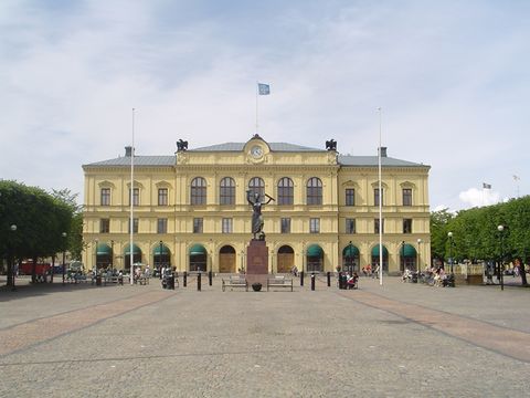
Karlstad Courthouse
