Municipality:Vänersborg
| Vänersborg | |
|---|---|
 | |
 Coat of arms of Vänersborg | |
| Country | Sweden |
| Region | Västra Götaland |
| Number of zones | 153 |
| Maximum PPH | 189 |
| Last updated | 2021-11-11 |
Vänersborg is a municipality in the region of Västra Götaland in Sweden. The municipality has about 39,700 inhabitants and is located in the provinces of Västergötland and Dalsland.
The river Göta älv flows through the municipality in a north-south direction.
Contents
Location
The municipality is located in the northwestern part of the province Västergötland and the southeastern part of Dalsland. Adjacent municipalities are, Uddevalla and Färgelanda in the west, Mellerud in the north, Grästorp in the east and Trollhättan and Lilla Edet in the south. To the east, the municipality has a maritime border with Lidköping municipality.
Urban areas
The urban area of Vänersborg is the largest with approximately 24,100 inhabitants and constitutes the municipality's central town. Other urban areas in the municipality are Brålanda, Frändefors, Katrinedal, Nordkroken and Vargön.
Zones
There are 153 turf zones in the municipality of Vänersborg, one of which is counted as a water zone, three train station zones, two monument zones, six holy zones, four bridge zones and two ruin zones.
The most taken zone is VänX which is centrally located at the pedestrian crossing in central Vänersborg.
Year in parentheses indicates year of creation.
 Water zones
 Train station zones
 Monument zones
 Holy zones
- FriendCross (2011) - Formerly called Friendcross
- Friendpark (2011)
- FrändeKyrka (2015)
- Strand (2013)
- UtblåstaLjus (2014)
- VassändaKyrka (2015)
 Bridge zones
- Baståbron (2016)
- Björkåsparken (2013)
- Brinkeberg (2013)
- Dalbobron (2013)
 Ruin zones
- Naglum (2016)
- VassändaRuin (2019)
Other zones
- Airbowzone (2014)
- Alunskiffer (2020)
- AndarnasSkepp (2011) - Formerly called Friendhigh
- BakTrafon (2014)
- Bastungen (2021)
- Bergagården (2015)
- Bergslagsåsen (2018)
- BirdLookout (2013)
- BjörkholmBuss (2014)
- Björkåstrappa (2020)
- Blåsut (2014)
- BlåsutSkog (2014)
- Bojortskajen (2013) - Formerly called Bojortkajen
- BorraOSpränga (2015)
- Botebäcken (2015)
- Botered (2017)
- Boteredszon (2014) - The 50th turf zone in the municipality.
- BrickHitZone (2014)
- Brudslöjan (2015)
- BrålandaBuske (2015)
- BrålandaPark (2015)
- Brålandazon (2015)
- ClothBarn (2014)
- DalboResident (2014)
- Daldaldal (2018)
- DarkWoods (2014)
- DatOldChapel (2015) - Formerly called Parkzon
- DatOldSchool (2013)
- Duell1816 (2017) - Formerly called Sommarvilja
- EnBokFlera (2018)
- FireWaterBrun (2020)
- Flanaden (2013)
- Flickskolan (2017)
- FlyingGoblin (2016)
- Forbondegatan (2021)
- FriendIsleII (2019)
- Förträffligt (2019)
- FöråddeKungen (2018)
- Gaddesanna (2017)
- GamlaIP (2015)
- GamlaUgnar (2015)
- GammalHamn (2015)
- Gropzon (2013)
- GrönaLagunen (2013)
- GötaGolf (2014)
- GötaView (2015)
- GötaÄlv (2014)
- Hagömaden (2020)
- Hallevi (2015)
- Hallezone (2011)
- HelenesBjörk (2017)
- HovHitter (2014)
- Hunnelake (2011) - The first turf zone in the municipality.
- HästView (2015)
- IngetBröllop (2014)
- Kanalen (2013)
- KannotGoThere (2013)
- KarlsGrav (2018)
- Karlsrost (2017)
- Keflaviksväg (2015)
- KungensKök (2020)
- Kyrkvägen (2015)
- LillaTornet (2016)
- Lillån (2015)
- LångaMaja (2019)
- Länsan (2014)
- Länsman (2014)
- Lärozon (2014)
- Margretezon (2014)
- MellanSkogen (2021)
- Nejlikan (2014)
- NewCrono (2014)
- Niklasberg (2014)
- Nordkrokrakan (2015)
- Nordpir (2015)
- Norgebryggan (2017)
- Nygårdsängen (2019)
- OlleniclasZon (2013)
- OnEnebacken (2017)
- Onsjözon (2014)
- Oxelpilgrop (2021)
- Parallell (2014)
- ParkToSea (2013)
- PetersPark (2014)
- PowerTower (2013) - The 10th turf zone in the municipality.
- Påfart (2015)
- RestadÖ (2019)
- RiverRelax (2019)
- Rulltrappan (2014)
- RättarnsBacke (2014)
- RöttÅGult (2018)
- Sandmarken (2019)
- Scoutzon (2015)
- Silvergranen (2013)
- Sjövikssänkan (2021)
- Skidstugan (2017)
- Skogzon (2015)
- Skräcklan (2013)
- Skräckle (2018)
- SlåMedRepIgen (2013)
- Smelly (2014)
- Solgården (2014)
- Solstugan (2014)
- SpaceInvaders (2013)
- Sparrespärren (2013)
- SportsHouse (2014)
- SteerRest (2014)
- Stjärnvägen (2021)
- Stolpskott (2021)
- Storkorset (2014) - Formerly called StorKorset
- Tornskugga (2013)
- Torpahallen (2014)
- Torszon (2015)
- TrångtVärre (2019)
- Tullare (2020)
- Turfstafett (2018)
- Ursand (2015)
- Urskogen (2015)
- VarningFörRas (2020)
- Vassbotten (2019)
- Vassbottenpir (2013)
- Vattenvägen (2013)
- VänersArena (2011) - Formerly called Friendfield
- Vänerspreik (2020)
- Vänerwalk (2018)
- Vänskogen (2013)
- VänX (2013)
- Växthusbacken (2021)
- WalkByWater (2016) - Formerly called Walkbywater
- Wolfpond (2011)
- Älgskogen (2018)
- Älvutsikten (2015)
- Önafors (2020)
- Öxnered (2014)
- Öxneredsvägen (2015)
Updated: 2021-11-11
Gallery
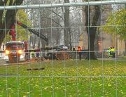
The zone Friendpark blocked by work.
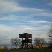
The zone BirdLookout is positioned near the lake Vänern.
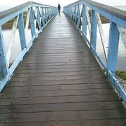
A bridge leading to the zone FriendIsleII.
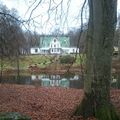
Björkåsparken is a nice park, little outside the center of Vänersborg, with two ponds.


