|
|
| Line 1: |
Line 1: |
| − | {{Zone
| |
| − | |name = Fightingbulls
| |
| − | |image = [[File:fightingbulls.JPG|350px]]
| |
| − | |terrain = [[hill]], [[gravel]]
| |
| − | |location = [[Norra Fäladen, Lund|Skåne]], [[Lund]], [[Sweden]]
| |
| − | |created = 2013-03-03
| |
| − | }}
| |
| | | | |
| − | This is the highest point in [http://sv.wikipedia.org/wiki/Lund Lund]. From here you can look at Denmark and Halland. Most probably you can see all the way to Blekinge region any clear day. Below the hill [http://sv.wikipedia.org/wiki/MAX-lab Max 4] is developed. To reach the top you need to advance 25 meters upwards from the street level at Klosterängsvägen.
| |
| − |
| |
| − | [[Category:Regions]]
| |
Revision as of 08:23, 12 July 2014
File history
Click on a date/time to view the file as it appeared at that time.
| Date/Time | Thumbnail | Dimensions | User | Comment |
|---|
| current | 16:50, 14 March 2013 | 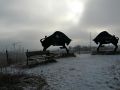 | 960 × 720 (74 KB) | Makkan (talk | contribs) | {{Zone |name = Fightingbulls |image = 350px |terrain = hill, gravel |location = Skåne, Lund, Sweden |created = 2013-03-03 }} This is the h... |
- You cannot overwrite this file.
File usage
The following page links to this file:
This file contains additional information, probably added from the digital camera or scanner used to create or digitize it.
If the file has been modified from its original state, some details may not fully reflect the modified file.
