Difference between revisions of "Zone:RothesLinn"
(Created page with "{{subst:Examplezone}}") |
m (→Placement) |
||
| (11 intermediate revisions by 2 users not shown) | |||
| Line 1: | Line 1: | ||
{{Zone | {{Zone | ||
| − | |name = | + | |name = RothesLinn |
| − | |image = [[File: | + | |image = [[File: RothesLinn.jpg|200px]] |
| − | |imagetext = | + | |imagetext = Rothes Linn waterfall |
| − | + | |difficulty = [[File: Difficulty5.png|frameless|90px]] | |
| − | + | |location = [[Municipality: Moray|Moray]], [[Region: Scotland|Scotland]], [[Country: United Kingdom|United Kingdom]] | |
| − | |difficulty = [[File: | + | |surface = [[Stone|Rocks]], [[Water|running water]], [[Grass|grassy river bank]] |
| − | |location = [[Municipality: | + | |created = 2021 |
| − | |surface = [[ | + | |trivia = A crossing of the burn and path to the waterfall were created by a community group in summer 2020. |
| − | |created = | ||
| − | |trivia = | ||
}} | }} | ||
| − | ''' | + | '''RothesLinn''' is a [[zone|turf zone]] in the [[municipality]] of [[Municipality: Moray|Moray]] in the [[region]] of [[Region: Scotland|Scotland]] in [[Country: United Kingdom|United Kingdom]]. |
== Placement == | == Placement == | ||
| − | The zone is located in the | + | The zone is located at a waterfall in a valley near to the village of [https://en.wikipedia.org/wiki/Rothes Rothes]. |
== Directions == | == Directions == | ||
| − | + | The zone is located near the [[Zone:Dounie|Dounie]] zone. From the Glenrothes distillery in the village, follow signs for 'Dounie Walk', passing through the Turf zone '[[Zone:Dounie|Dounie]]' until the path splits in two. Do not take the path going back uphill. It leads to a viewpoint high above the waterfall. The waterfall is usually only visible from here in winter because of trees. Instead, turn right and follow the path downhill towards the burn and turn left where trees have been cleared to create a path. Cross the burn and walk along the path to the left. Cross the burn again by stepping on large rocks and the waterfall will eventually come in to view. GPS signal can be patchy due to the location but with a bit of perseverance the zone can be taken. | |
== Sightseeing == | == Sightseeing == | ||
| − | + | Although Glenrothes Distillery is not open to the public for visits, the nearby Glen Grant distillery does offer visits, a shop and extensive gardens. The Turf zone '[[Zone:Glenniezone|Glenniezone]]' is located at Glen Grant on the path from the car park to the visitor centre. | |
| − | == | + | == Rothes Linn waterfall == |
| − | + | The image gallery contains a description of the Rothes Linn waterfall taken from an information panel at the viewpoint mentioned above. | |
| − | == | + | == Image gallery == |
| − | + | <gallery mode="packed" heights=240px> | |
| − | + | File: Info panel.jpg | Rothes Linn waterfall information panel | |
| − | + | File: Rothes Burn.jpg | Rothes Burn seen from RothesLinn zone | |
| − | |||
| − | |||
| − | |||
| − | |||
| − | |||
| − | |||
| − | |||
| − | |||
| − | |||
| − | |||
| − | File: | ||
| − | File: | ||
| − | |||
| − | |||
</gallery> | </gallery> | ||
== External links == | == External links == | ||
| − | * [https://warded.se/turf/zones.php?zone= | + | * [https://warded.se/turf/zones.php?zone=RothesLinn RothesLinn(Warded)] |
| − | + | * [https://www.walkhighlands.co.uk/moray/dounie-rothes.shtml Detailed descrption of the Dounie walk (Walk Highlands)]. | |
| − | |||
| − | * [ | ||
| − | |||
| − | |||
| − | |||
| − | |||
| − | + | [[Category:Zones]] | |
| − | [[Category: Zones]] | + | [[Category:United Kingdom]] |
| − | [[Category: | + | [[Category:Scotland]] |
| − | [[Category: | + | [[Category:Moray]] |
| − | [[Category: | + | [[Category:Waterfalls]] |
| − | [[Category: | + | [[Category:2021]] |
| − | [[Category: | ||
Latest revision as of 08:57, 25 June 2021
| RothesLinn | |
|---|---|
 Rothes Linn waterfall | |
| Information | |
| Difficulty | |
| Location | Moray, Scotland, United Kingdom |
| Surface | Rocks, running water, grassy river bank |
| Created | 2021 |
| Trivia | A crossing of the burn and path to the waterfall were created by a community group in summer 2020. |
| RothesLinn at Turfgame.com | |
RothesLinn is a turf zone in the municipality of Moray in the region of Scotland in United Kingdom.
Contents
Placement[edit]
The zone is located at a waterfall in a valley near to the village of Rothes.
Directions[edit]
The zone is located near the Dounie zone. From the Glenrothes distillery in the village, follow signs for 'Dounie Walk', passing through the Turf zone 'Dounie' until the path splits in two. Do not take the path going back uphill. It leads to a viewpoint high above the waterfall. The waterfall is usually only visible from here in winter because of trees. Instead, turn right and follow the path downhill towards the burn and turn left where trees have been cleared to create a path. Cross the burn and walk along the path to the left. Cross the burn again by stepping on large rocks and the waterfall will eventually come in to view. GPS signal can be patchy due to the location but with a bit of perseverance the zone can be taken.
Sightseeing[edit]
Although Glenrothes Distillery is not open to the public for visits, the nearby Glen Grant distillery does offer visits, a shop and extensive gardens. The Turf zone 'Glenniezone' is located at Glen Grant on the path from the car park to the visitor centre.
Rothes Linn waterfall[edit]
The image gallery contains a description of the Rothes Linn waterfall taken from an information panel at the viewpoint mentioned above.
Image gallery[edit]
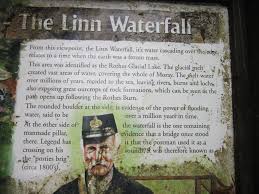
Rothes Linn waterfall information panel
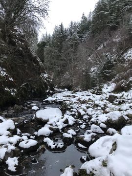
Rothes Burn seen from RothesLinn zone

