Difference between revisions of "Zone:StoodleyPike"
(Created page with " {{subst:Examplezone}}") |
|||
| (10 intermediate revisions by 2 users not shown) | |||
| Line 1: | Line 1: | ||
| − | + | {{Zone | |
| − | |name = | + | |name = StoodleyPike |
| − | |image = [[File: | + | |image = [[File: Pike.jpg|350px]] |
| − | |imagetext = | + | |imagetext = Stoodley Pike Monument |
| − | |symbol = [[File: | + | |symbol = [[File: Zontyp06.png|60px]] |
| − | |symboltext = ( | + | |symboltext = ([[Monument]]) |
| − | |difficulty = [[File: | + | |difficulty = [[File: Difficulty4.png|frameless|90px]] |
| − | |location = [[Municipality: | + | |location = [[Municipality: West Yorkshire]], [[Region: Yorkshire & The Humber]], [[Country: United Kingdom]] |
| − | |surface = [[ | + | |surface = [[Gravel]], [[Soil]] |
| − | |created = | + | |created = 2022-06-05 |
| − | |trivia = | + | |trivia = The monument is a Grade II listed commemorates the surrender of Paris to the Allies after the Napoleonic Wars. |
}} | }} | ||
| − | ''' | + | '''StoodleyPike''' is a [[zone|turf zone]] in the [[municipality]] of [[Municipality|West Yorkshire]] in the [[region]] of [[Yorkshire & The Humber]] in [[United Kingdom]]. |
== Placement == | == Placement == | ||
| − | The zone is located | + | The zone is located on the Pennine Way west of Halifax. |
== Directions == | == Directions == | ||
| − | + | The Pike can be accessed from a number of directions, including from: Mankinholes in Todmorden; Charlestown in Hebden Bridge; and Cragg Vale in Mytholmroyd. There is no vehicular or bicycle access to the monument. | |
| − | == | + | == The place == |
| − | + | Stoodley Pike, or "the Pike", upon which the Stoodley Pike monument stands, is a 402m hill on the Pennine Way in West Yorkshire. The monument itself is 37m tall, with a 39-step spiral staircase climbing 12m to allow visitors to access a balcony running around its outer edge. The Pike can be seen across the moors from many vantage points around the Upper Calder Valley. It was designed in 1854 by local architect John Green and completed at the end of the Crimean War in 1856. Prior to the current stone structure, an earlier monument was built on a spot closer to the edge of the hill. This was commenced in 1814 to commemorate the defeat of Napoleon, but collapsed after being struck by lightning. | |
| − | == | + | == Image gallery == |
| − | + | <gallery mode="packed" heights=240px> | |
| − | + | File: SnowPike.jpg | The monument in winter | |
| − | |||
| − | |||
| − | |||
| − | |||
| − | |||
| − | |||
| − | |||
| − | |||
| − | |||
| − | |||
| − | |||
| − | == | ||
| − | |||
| − | |||
| − | File: | ||
| − | |||
| − | |||
| − | |||
</gallery> | </gallery> | ||
== External links == | == External links == | ||
| − | * [https://warded.se/turf/zones.php?zone= | + | * [https://warded.se/turf/zones.php?zone=StoodleyPike StoodleyPike(Warded)] |
| − | |||
| − | |||
| − | |||
| − | |||
| − | == | + | == Nearby zones == |
| − | + | [[Zone:ThisMoorDoth|ThisMoorDoth]] | |
| − | |||
[[Category: Zones]] | [[Category: Zones]] | ||
| − | [[Category: | + | [[Category: Monument Zones]] |
| − | [[Category: | + | [[Category: United Kingdom]] |
| − | [[Category: | + | [[Category: Yorkshire & The Humber]] |
| − | [[Category: | + | [[Category: West Yorkshire]] |
| − | [[Category: | + | [[Category: 2022]] |
Latest revision as of 15:02, 4 January 2023
| StoodleyPike | |
|---|---|
 Stoodley Pike Monument | |
 (Monument) | |
| Information | |
| Difficulty | |
| Location | Municipality: West Yorkshire, Region: Yorkshire & The Humber, Country: United Kingdom |
| Surface | Gravel, Soil |
| Created | 2022-06-05 |
| Trivia | The monument is a Grade II listed commemorates the surrender of Paris to the Allies after the Napoleonic Wars. |
| StoodleyPike at Turfgame.com | |
StoodleyPike is a turf zone in the municipality of West Yorkshire in the region of Yorkshire & The Humber in United Kingdom.
Placement[edit]
The zone is located on the Pennine Way west of Halifax.
Directions[edit]
The Pike can be accessed from a number of directions, including from: Mankinholes in Todmorden; Charlestown in Hebden Bridge; and Cragg Vale in Mytholmroyd. There is no vehicular or bicycle access to the monument.
The place[edit]
Stoodley Pike, or "the Pike", upon which the Stoodley Pike monument stands, is a 402m hill on the Pennine Way in West Yorkshire. The monument itself is 37m tall, with a 39-step spiral staircase climbing 12m to allow visitors to access a balcony running around its outer edge. The Pike can be seen across the moors from many vantage points around the Upper Calder Valley. It was designed in 1854 by local architect John Green and completed at the end of the Crimean War in 1856. Prior to the current stone structure, an earlier monument was built on a spot closer to the edge of the hill. This was commenced in 1814 to commemorate the defeat of Napoleon, but collapsed after being struck by lightning.
Image gallery[edit]
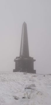
The monument in winter
