Difference between revisions of "Zone:Highhope"
m |
(Revised. Removed stub) |
||
| (8 intermediate revisions by 3 users not shown) | |||
| Line 1: | Line 1: | ||
| − | |||
{{Zone | {{Zone | ||
|name = Highhope | |name = Highhope | ||
| − | | | + | |image = [[File: highhope.jpg|350px]] |
| − | | | + | |imagetext = View south. Photo: [[User: Jockatim|Jockatim]] |
| − | | | + | |symbol = [[File: Zontyp09.png|60px]] |
| + | |symboltext = [[Bridge zone]] | ||
| + | |difficulty = [[File: Difficulty1.png|90px]] | ||
| + | |location = [[Municipality: Stockholm|Stockholm]], [[Region: Stockholm|Stockholm]], [[Country: Sweden|Sweden]] | ||
| + | |surface = [[Cycle path|Pedestrian and cycle path]] | ||
|created = 2011-03-16 | |created = 2011-03-16 | ||
| + | |trivia = | ||
}} | }} | ||
| − | + | '''Highhope''' is a [[turf zone]] in the [[municipality]] of [[Municipality: Stockholm|Stockholm]] in the [[region]] of [[Region: Stockholm|Stockholm]] in [[Country: Sweden|Sweden]] and is counted as a [[bridge zone]]. | |
| − | == | + | == Placement == |
| − | + | This [[bridge zone]] is located at the [[cycle path|pedestrian and cycle path]] on the highest point of [https://en.wikipedia.org/wiki/Alviksbron Alviksbron], a [https://en.wikipedia.org/wiki/Light_rail light rail] [[bridge]] for [https://en.wikipedia.org/wiki/Tv%C3%A4rbanan Tvärbanan] between the island of [https://en.wikipedia.org/wiki/Stora_Essingen Stora Essingen] and the residential district of [https://en.wikipedia.org/wiki/Alvik Alvik], west of central [[Stockholm]]. | |
| − | == | + | == Alviksbron == |
| − | [ | + | '''Alviksbron''' (Swedish for ''The Alvik Bridge'') is a [https://en.wikipedia.org/wiki/Box_girder_bridge box girder bridge] in central [[Stockholm]], [[Country: Sweden|Sweden]]. Stretching over Oxhålssundet, it connects [https://en.wikipedia.org/wiki/Stora_Essingen Stora Essingen] island to the western suburb [https://en.wikipedia.org/wiki/Bromma Bromma]. Built 1996-1998 by the [https://en.wikipedia.org/wiki/Nordic_Construction_Company Nordic Construction Company] at a cost of 180 million [https://en.wikipedia.org/wiki/Swedish_Krona SEK], it has served the [https://en.wikipedia.org/wiki/Tv%C3%A4rbanan Tvärbanan] [https://en.wikipedia.org/wiki/Light_rail light rail] line and pedestrians and bicyclists since its inauguration in August 2000. The name is derived from [https://en.wikipedia.org/wiki/Alvik Alvik], originally a local [https://en.wikipedia.org/wiki/Manor_house manor house] built in 1819 and demolished in 1930. |
| − | [[Category:Sweden]] | + | The bridge is 400 metres in length with a 140-metre central span and a horizontal clearance of 24 metres. The underside of the bridge tie forms an [https://en.wikipedia.org/wiki/Arch arch] intended to make the bridge as slender as possible. The two pillars standing in the water each consist of two thin concrete plates dressed in two-quarters brick with a common concrete foundation. They are illuminated after dark.<ref>[https://en.wikipedia.org/wiki/Alviksbron Wikipedia]</ref> |
| − | [[sv:Zon:Highhope]] | + | |
| + | == Nearby zones == | ||
| + | * [[Zone: EssKonferens|EssKonferens]] (in the East) | ||
| + | * [[Zone: Essinge|Essinge]] (in the southeast) | ||
| + | * [[Zone: CloverField|CloverField]] (in the southwest) | ||
| + | * [[Zone: Snäckparken|Snäckparken]] (in West) | ||
| + | * [[Zone: AlvikStrand|AlvikStrand]] (in the northwest) | ||
| + | * [[Zone: Ågust|Ågust]] [[File: Zontyp06.png|18px]] (in the north) | ||
| + | |||
| + | == Gallery == | ||
| + | <gallery mode="packed" heights=240px> | ||
| + | Zon Highhope-02.jpg|View south over Stora Essingen.<br>Photo: [[User: Celtikcross|Celtikcross]] | ||
| + | </gallery> | ||
| + | |||
| + | == External links == | ||
| + | * [https://warded.se/turf/zones.php?zone=Highhope Highhope (Warded)] | ||
| + | * [https://en.wikipedia.org/wiki/Tv%C3%A4rbanan Tvärbanan (Wikipedia)] | ||
| + | |||
| + | == References == | ||
| + | |||
| + | [[Category: Zones]] | ||
| + | [[Category: Bridge Zones]] | ||
| + | [[Category: Sweden]] | ||
| + | [[Category: Stockholm]] | ||
| + | [[Category: 2011]] | ||
| + | |||
| + | [[sv: Zon: Highhope]] | ||
Latest revision as of 11:41, 29 May 2021
| Highhope | |
|---|---|
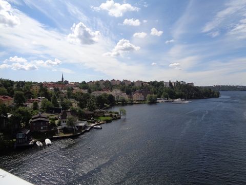
 View south. Photo: Jockatim | |
 | |
| Information | |
| Difficulty | |
| Location | Stockholm, Stockholm, Sweden |
| Surface | Pedestrian and cycle path |
| Created | 2011-03-16 |
| Highhope at Turfgame.com | |
Highhope is a turf zone in the municipality of Stockholm in the region of Stockholm in Sweden and is counted as a bridge zone.
Placement[edit]
This bridge zone is located at the pedestrian and cycle path on the highest point of Alviksbron, a light rail bridge for Tvärbanan between the island of Stora Essingen and the residential district of Alvik, west of central Stockholm.
Alviksbron[edit]
Alviksbron (Swedish for The Alvik Bridge) is a box girder bridge in central Stockholm, Sweden. Stretching over Oxhålssundet, it connects Stora Essingen island to the western suburb Bromma. Built 1996-1998 by the Nordic Construction Company at a cost of 180 million SEK, it has served the Tvärbanan light rail line and pedestrians and bicyclists since its inauguration in August 2000. The name is derived from Alvik, originally a local manor house built in 1819 and demolished in 1930.
The bridge is 400 metres in length with a 140-metre central span and a horizontal clearance of 24 metres. The underside of the bridge tie forms an arch intended to make the bridge as slender as possible. The two pillars standing in the water each consist of two thin concrete plates dressed in two-quarters brick with a common concrete foundation. They are illuminated after dark.[1]
Nearby zones[edit]
- EssKonferens (in the East)
- Essinge (in the southeast)
- CloverField (in the southwest)
- Snäckparken (in West)
- AlvikStrand (in the northwest)
- Ågust
 (in the north)
Gallery[edit]
View south over Stora Essingen.
Photo: Celtikcross
