Difference between revisions of "Municipality:Örebro"
(Created page with "{{Municipality |name = Örebro |image = 300px |imagetext = The municipality of Örebro in the region of Region...") |
(New zones) |
||
| Line 5: | Line 5: | ||
|symbol = [[File: Örebro kommunvapen.png|60px]] | |symbol = [[File: Örebro kommunvapen.png|60px]] | ||
|symboltext = Coat of arms | |symboltext = Coat of arms | ||
| − | |country = [[Country: Sweden|Sweden]] [[File: Sverige flagga.png|x12px | + | |country = [[Country: Sweden|Sweden]] [[File: Sverige flagga.png|x12px]] |
|region = [[Region: Örebro|Örebro]] | |region = [[Region: Örebro|Örebro]] | ||
| − | |numberofzones = | + | |numberofzones = 563 |
| − | |maxpph = | + | |maxpph = 2347 |
| − | |updated = 2021- | + | |updated = 2021-08-28 |
}} | }} | ||
| − | '''Örebro''' is a [[municipality]] in the [[region]] of [[Region: Örebro|Örebro]] in [[Country: Sweden|Sweden]]. The municipality has about 156,000 inhabitants and is located for the most part in the province of Närke, while a smaller part of the municipality is located in the province of Västmanland. | + | '''Örebro''' is a [[municipality]] in the [[region]] of [[Region: Örebro|Örebro]] in [[Country: Sweden|Sweden]]. The municipality has about 156,000 inhabitants and is located for the most part in the [[province]] of Närke, while a smaller part of the municipality is located in the province of Västmanland. |
== Location == | == Location == | ||
| − | Örebro municipality is located in the central and eastern parts of the province of Närke, except for the northernmost part (Ervalla district), which is located in Västmanland. The municipality is located at the western part of Lake Hjälmaren where the Svartån flows out from the west. | + | Örebro municipality is located in the central and eastern parts of the [[province]] of Närke, except for the northernmost part (Ervalla district), which is located in Västmanland. The municipality is located at the western part of Lake Hjälmaren where the Svartån flows out from the west. |
The municipality borders the municipalities [[Municipality: Arboga|Arboga]] in [[Region: Västmanland|Västmanland County]], [[Municipality: Vingåker|Vingåker]] in [[Region: Södermanland|Södermanland County]] and [[Municipality: Finspång|Finspång]] in [[Region: Östergötland|Östergötlands County]] in the east. In addition to [[Municipality: Hallsberg|Hallsberg]], [[Municipality: Kumla|Kumla]], [[Municipality: Lekeberg|Lekeberg]] and [[Municipality: Karlskoga|Karlskoga]] in the southwest and to [[Municipality: Nora|Nora]] and [[Municipality: Lindesberg|Lindesberg]], all in [[Region: Örebro|Örebro County]] in the north. | The municipality borders the municipalities [[Municipality: Arboga|Arboga]] in [[Region: Västmanland|Västmanland County]], [[Municipality: Vingåker|Vingåker]] in [[Region: Södermanland|Södermanland County]] and [[Municipality: Finspång|Finspång]] in [[Region: Östergötland|Östergötlands County]] in the east. In addition to [[Municipality: Hallsberg|Hallsberg]], [[Municipality: Kumla|Kumla]], [[Municipality: Lekeberg|Lekeberg]] and [[Municipality: Karlskoga|Karlskoga]] in the southwest and to [[Municipality: Nora|Nora]] and [[Municipality: Lindesberg|Lindesberg]], all in [[Region: Örebro|Örebro County]] in the north. | ||
== Urban areas == | == Urban areas == | ||
| − | The urban area [[Örebro]] constitutes the municipality's central town and city of residence in [[Region: Örebro|Örebro County]] and is located in the province of Närke. The city celebrated its | + | The urban area [[Örebro]] constitutes the municipality's central town and city of residence in [[Region: Örebro|Örebro County]] and is located in the [[province]] of Närke. The city celebrated its 750th anniversary in [[2015]], although it is unclear whether the city was actually founded in 1265. In the center is the [[castle]], which dates back to the 13th century. |
Other urban areas in the municipality are [https://en.wikipedia.org/wiki/Askersby Askersby], [https://en.wikipedia.org/wiki/Ekeby-Almby Ekeby-Almby], [https://en.wikipedia.org/wiki/Garphyttan Garphyttan], [https://en.wikipedia.org/wiki/Glanshammar Glanshammar], [https://en.wikipedia.org/wiki/Hampetorp Hampetorp], [https://en.wikipedia.org/wiki/Hovsta Hovsta], [https://en.wikipedia.org/wiki/Kilsmo Kilsmo], [https://en.wikipedia.org/wiki/Latorpsbruk Latorpsbruk], [https://en.wikipedia.org/wiki/Norra_Bro Norra Bro], [https://en.wikipedia.org/wiki/Odensbacken Odensbacken], [https://en.wikipedia.org/wiki/Stora_Mell%C3%B6sa Stora Mellösa], [https://en.wikipedia.org/wiki/Vintrosa Vintrosa], part of and [https://en.wikipedia.org/wiki/%C3%96lmbrotorp Ölmbrotorp]. | Other urban areas in the municipality are [https://en.wikipedia.org/wiki/Askersby Askersby], [https://en.wikipedia.org/wiki/Ekeby-Almby Ekeby-Almby], [https://en.wikipedia.org/wiki/Garphyttan Garphyttan], [https://en.wikipedia.org/wiki/Glanshammar Glanshammar], [https://en.wikipedia.org/wiki/Hampetorp Hampetorp], [https://en.wikipedia.org/wiki/Hovsta Hovsta], [https://en.wikipedia.org/wiki/Kilsmo Kilsmo], [https://en.wikipedia.org/wiki/Latorpsbruk Latorpsbruk], [https://en.wikipedia.org/wiki/Norra_Bro Norra Bro], [https://en.wikipedia.org/wiki/Odensbacken Odensbacken], [https://en.wikipedia.org/wiki/Stora_Mell%C3%B6sa Stora Mellösa], [https://en.wikipedia.org/wiki/Vintrosa Vintrosa], part of and [https://en.wikipedia.org/wiki/%C3%96lmbrotorp Ölmbrotorp]. | ||
== Zones == | == Zones == | ||
| − | There are [https://lundkvist.com/?country=se®ion=131&city=%C3%96rebro | + | There are [https://lundkvist.com/?country=se®ion=131&city=%C3%96rebro 563] [[turf zones]] in the municipality of Örebro, six of which are counted as [[winner zones]], three [[water zones]], one [[train station zone]], four [[monument zones]], 18 [[holy zones]], 24 [[bridge zones]], one [[castle zone]] and two [[ruin zones]]. |
The most taken zone is [[Zone: GreatSquare|GreatSquare]] which is located on Stortorget in central [[Örebro]]. | The most taken zone is [[Zone: GreatSquare|GreatSquare]] which is located on Stortorget in central [[Örebro]]. | ||
| Line 31: | Line 31: | ||
Year in parentheses indicates year of creation. | Year in parentheses indicates year of creation. | ||
| − | === [[File: Zontyp02.png| | + | === [[File: Zontyp02.png|24px]] [[Winner zones]] === |
* [[Zone: floraFlora|floraFlora]] ([[2019]]) - [[Round 111]] by [[User: floramcml|floramcml]] | * [[Zone: floraFlora|floraFlora]] ([[2019]]) - [[Round 111]] by [[User: floramcml|floramcml]] | ||
* [[Zone: KremelZone|KremelZone]] ([[2014]]) - [[Round 43]] by [[User: Turfsmurfen.|Turfsmurfen.]] | * [[Zone: KremelZone|KremelZone]] ([[2014]]) - [[Round 43]] by [[User: Turfsmurfen.|Turfsmurfen.]] | ||
| Line 39: | Line 39: | ||
* [[Zone: yxasParkzon|yxasParkzon]] ([[2014]]) - [[Round 44]] by [[User: yxa|yxa]] | * [[Zone: yxasParkzon|yxasParkzon]] ([[2014]]) - [[Round 44]] by [[User: yxa|yxa]] | ||
| − | === [[File: Zontyp03.png| | + | === [[File: Zontyp03.png|24px]] [[Water zones]] === |
* [[Zone: Dimbobaden|Dimbobaden]] ([[2014]]) | * [[Zone: Dimbobaden|Dimbobaden]] ([[2014]]) | ||
* [[Zone: Lången|Lången]] ([[2015]]) | * [[Zone: Lången|Lången]] ([[2015]]) | ||
* [[Zone: Ånnabada|Ånnabada]] ([[2015]]) | * [[Zone: Ånnabada|Ånnabada]] ([[2015]]) | ||
| − | === [[File: Zontyp04.png| | + | === [[File: Zontyp04.png|24px]] [[Train station zones]] === |
* [[Zone: PennyTrain|PennyTrain]] ([[2011]]) | * [[Zone: PennyTrain|PennyTrain]] ([[2011]]) | ||
| − | === [[File: Zontyp06.png| | + | === [[File: Zontyp06.png|24px]] [[Monument zones]] === |
* [[Zone: Engelbrekt|Engelbrekt]] ([[2020]]) | * [[Zone: Engelbrekt|Engelbrekt]] ([[2020]]) | ||
* [[Zone: Formel1|Formel1]] ([[2013]]) | * [[Zone: Formel1|Formel1]] ([[2013]]) | ||
| Line 53: | Line 53: | ||
* [[Zone: PetrisPetare|PetrisPetare]] ([[2014]]) | * [[Zone: PetrisPetare|PetrisPetare]] ([[2014]]) | ||
| − | === [[File: Zontyp07.png| | + | === [[File: Zontyp07.png|24px]] [[Holy zones]] === |
* [[Zone: AdoChurch|AdoChurch]] ([[2019]]) | * [[Zone: AdoChurch|AdoChurch]] ([[2019]]) | ||
* [[Zone: AlmbyKyrka|AlmbyKyrka]] ([[2017]]) | * [[Zone: AlmbyKyrka|AlmbyKyrka]] ([[2017]]) | ||
| Line 73: | Line 73: | ||
* [[Zone: ValidChurch|ValidChurch]] ([[2016]]) | * [[Zone: ValidChurch|ValidChurch]] ([[2016]]) | ||
| − | === [[File: Zontyp09.png| | + | === [[File: Zontyp09.png|24px]] [[Bridge zones]] === |
* [[Zone: Almbridge|Almbridge]] ([[2016]]) | * [[Zone: Almbridge|Almbridge]] ([[2016]]) | ||
* [[Zone: BeachBridge|BeachBridge]] ([[2012]]) | * [[Zone: BeachBridge|BeachBridge]] ([[2012]]) | ||
| Line 99: | Line 99: | ||
* [[Zone: Västhagabron|Västhagabron]] ([[2013]]) | * [[Zone: Västhagabron|Västhagabron]] ([[2013]]) | ||
| − | === [[File: Zontyp10.png| | + | === [[File: Zontyp10.png|24px]] [[Castle zones]] === |
* [[Zone: ÖrebroSlott|ÖrebroSlott]] ([[2016]]) | * [[Zone: ÖrebroSlott|ÖrebroSlott]] ([[2016]]) | ||
| − | === [[File: Zontyp11.png| | + | === [[File: Zontyp11.png|24px]] [[Ruin zones]] === |
* [[Zone: GlansGravar|GlansGravar]] ([[2018]]) | * [[Zone: GlansGravar|GlansGravar]] ([[2018]]) | ||
* [[Zone: Nastastenen|Nastastenen]] ([[2017]]) | * [[Zone: Nastastenen|Nastastenen]] ([[2017]]) | ||
| Line 108: | Line 108: | ||
=== Other zones === | === Other zones === | ||
| − | ''Updated: 2021- | + | ''Updated: 2021-08-28'' |
== Gallery == | == Gallery == | ||
| Line 116: | Line 116: | ||
SvampZone.jpg|The water tower The mushroom seen from the zone [[Zone: SvampZone|SvampZone]]. | SvampZone.jpg|The water tower The mushroom seen from the zone [[Zone: SvampZone|SvampZone]]. | ||
HagmarksX.jpg|The zone [[Zone: HagmarksX|HagmarksX]]. | HagmarksX.jpg|The zone [[Zone: HagmarksX|HagmarksX]]. | ||
| − | VenaLagunen2.jpg|The zone [[Zone: VenaLagunen|VenaLagunen]] in Oset and Rynningeviken nature reserve. | + | VenaLagunen2.jpg|The zone [[Zone: VenaLagunen|VenaLagunen]] in Oset and Rynningeviken [[nature reserve]]. |
</gallery> | </gallery> | ||
Latest revision as of 10:47, 28 August 2021
| Örebro | |
|---|---|
 | |
 Coat of arms | |
| Country | Sweden |
| Region | Örebro |
| Number of zones | 563 |
| Maximum PPH | 2347 |
| Last updated | 2021-08-28 |
Örebro is a municipality in the region of Örebro in Sweden. The municipality has about 156,000 inhabitants and is located for the most part in the province of Närke, while a smaller part of the municipality is located in the province of Västmanland.
Contents
Location[edit]
Örebro municipality is located in the central and eastern parts of the province of Närke, except for the northernmost part (Ervalla district), which is located in Västmanland. The municipality is located at the western part of Lake Hjälmaren where the Svartån flows out from the west.
The municipality borders the municipalities Arboga in Västmanland County, Vingåker in Södermanland County and Finspång in Östergötlands County in the east. In addition to Hallsberg, Kumla, Lekeberg and Karlskoga in the southwest and to Nora and Lindesberg, all in Örebro County in the north.
Urban areas[edit]
The urban area Örebro constitutes the municipality's central town and city of residence in Örebro County and is located in the province of Närke. The city celebrated its 750th anniversary in 2015, although it is unclear whether the city was actually founded in 1265. In the center is the castle, which dates back to the 13th century.
Other urban areas in the municipality are Askersby, Ekeby-Almby, Garphyttan, Glanshammar, Hampetorp, Hovsta, Kilsmo, Latorpsbruk, Norra Bro, Odensbacken, Stora Mellösa, Vintrosa, part of and Ölmbrotorp.
Zones[edit]
There are 563 turf zones in the municipality of Örebro, six of which are counted as winner zones, three water zones, one train station zone, four monument zones, 18 holy zones, 24 bridge zones, one castle zone and two ruin zones.
The most taken zone is GreatSquare which is located on Stortorget in central Örebro.
Year in parentheses indicates year of creation.
 Winner zones[edit]
- floraFlora (2019) - Round 111 by floramcml
- KremelZone (2014) - Round 43 by Turfsmurfen.
- Loafalicious (2014) - Round 47 by Loaf
- LoafsBackyard (2013) - Round 38 by Loaf
- Yxa2 (2014) - Round 48 by yxa
- yxasParkzon (2014) - Round 44 by yxa
 Water zones[edit]
 Train station zones[edit]
 Monument zones[edit]
- Engelbrekt (2020)
- Formel1 (2013)
- GreatSquare (2011)
- PetrisPetare (2014)
 Holy zones[edit]
- AdoChurch (2019)
- AlmbyKyrka (2017)
- AskerKyrka (2014)
- Axberg (2020)
- DigChurch (2016)
- EkerKyrka (2017)
- Elims (2020)
- Glanshammar (2017)
- HovstaKyrka (2013)
- Krematoriezon (2014)
- Kullkyrkan (2014)
- LännäsKyrka (2017)
- MosjöKyrka (2013)
- MällösaKyrka (2014)
- OlausPetriz (2013)
- Rinkaby (2017)
- Tysslingen (2016)
- ValidChurch (2016)
 Bridge zones[edit]
- Almbridge (2016)
- BeachBridge (2012)
- BigBridge (2010)
- BlackStream (2016)
- Brevensbro (2016)
- Brobanan (2020)
- BroÖverLillån (2014)
- CastleBridge (2012)
- EfterSnurr (2020)
- Kvarnbridge (2013)
- Köpbergabron (2014)
- Lillbäcken (2013)
- LindBridge (2015)
- MaraboooRiver (2013)
- NaturensHus (2013)
- OdenBro (2012)
- OdensLillaBro (2014)
- Oxhagsbron (2018)
- Papposkuni (2017)
- PeaceBridge (2012)
- RynningeLilla (2014)
- SvartaFallet (2014)
- Västerledbron (2016)
- Västhagabron (2013)
 Castle zones[edit]
 Ruin zones[edit]
Other zones[edit]
Updated: 2021-08-28
Gallery[edit]
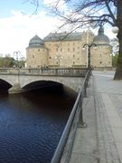
Örebro Castle and the zone BigBridge.
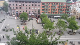
Våghustorget with the zone Våghustorget.

The water tower The mushroom seen from the zone SvampZone.
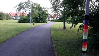
The zone HagmarksX.
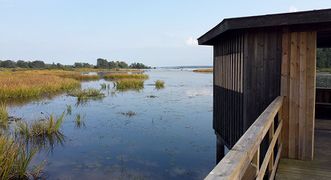
The zone VenaLagunen in Oset and Rynningeviken nature reserve.


